 |
 |

Subject: V Is For Visitors
Journal: The Times Date: May 1995 Author: Clive Fewins
Ned Prideaux has a handful of mazzard trees in his orchard near the village of Landkey in north Devon. “The mazzards
are like cherries, only almost black in colour, twice the size and twice as tasty,” he says.
Picture: J. Allan Cash 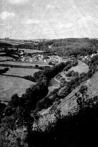 Tarka country: the River Torridge winds through the countryside around Great Torrington.
Mr Prideaux, 93, can remember the days when Landkey was a mass of pinkish-white mazzard blossom in late May. But all that
has now gone. After the Second World War farmers were encouraged to grub out less economic fruit trees and nearly all the
mazzards in the village disappeared.
“In a few years, as the older generation dies off, the word mazzard may come to mean very little in Landkey as new people
move in,” Danny Hughes says. Mr Hughes is a specialist employed by Devon County Council and Common Ground, an environmental
charity, to organise the North Devon Local Distinctiveness campaign, and high on his list of actions is the recreation of
a mazzard orchard in Landkey.
The plan to replant mazzards, plus three traditional varieties of local apple, is part of a novel scheme Mr Hughes has devised
to draw the attention of both local people and visitors to the richness and diversity of life in the rolling countryside
characteristic of north Devon. The scheme is called the Alphabet Parishes project, and it involves 26 villages – one for each
letter of the alphabet – in 200 square miles of country bounded by the coast to the north, Exmoor to the east, and the River
Torridge to the west.
The parishes have been chosen because they each represent something special, or highly characteristic of the area. To draw
attention to the attractiveness of the area and to encourage tourists, Mr Hughes and his colleagues have created a “passport”,
designed to make the visitor stop, linger and explore.
The passport has to be stamped at a predetermined place in the village – usually the village shop, post office or pub,
details of which are given at the foot of each page. Before this, however, the passport holder has to scour the village to
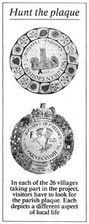
find the Alphabet Parishes plaque. There is a different design for each village and the plaques, most of which have recently
been installed on the walls of buildings, have been made by a local potter and reflect an aspect of parish life. For Landkey,
not surprisingly, the plaque depicts a mazzard.
The scheme is called the Alphabet Parishes project because each of the villages chooses a letter that refers to some
distinctive element of its life. In Landkey the letter is M for mazzard, while in Shebbear the letter is B – for boulder.
Under an old oak tree in the centre of the village there is a large boulder that, according to local legend, was dropped
by the devil. After dark on November 5 every year local bellringers sound a cacophonous peal on the church bells and then,
using crowbars, they turn the boulder over.
In Taddiport L stands for the ancient leper fields, where inmates from the leper hospital in the village worked in the
13th century. It being Devon, fields feature prominently in many of the parish descriptions, such as that for the village
of Sheepwash, home of the best-maintained strip fields (S) in the country. They can be seen on the gentle valleyside sloping
down to the River Torridge, each marked by a hedge.
The tiny village of Molland on the fringes of Exmoor claims the letter R – for Red Ruby, a famous breed of cattle originally
bred there and still exported all over the world. In the nearby village of North Molton you spy the letter I, for iron, as
mining for iron, lead and copper played a major part in the history of the village until the early 18OOs.
The market town of South Molton, four miles to the south-west, is regarded as the gateway (G) to Exmoor, which lies to the
north, and a good base from which to explore north Devon. The town contains many Georgian buildings and some good places to eat.
The name Tarka can mean only one thing to readers of Henry Williamson, and the small town of Great Torrington 15 miles to the
west of South Molton boasts the letter T. The 1927 classic Tarka the Otter gave rise to a new long-distance footpath, opened
in 1992, based on the rivers Taw and Torridge – the “country of the two rivers” – in which the book is set. With the aid of
the Tarka Trail Walkers’ Guide, which includes sections written by Richard Williamson, son of Henry, many of the alphabet
parishes can be incorporated into sections of the trail. Useful B&B addresses are given in the guide.
There is also a Tarka Project, whose staff created the Tarka trail and helped Mr Hughes to set up the Alphabet Parishes
scheme. The project encourages others to do environmental renewal work. A good example is the plan to clear much of the
scrub and bracken that has grown up over much of the 360 acres of Torrington Commons in the 20 years since animals grazed
there, and return the area to grass and heathland.
The project also encourages people to visit north Devon for quiet recreation while conserving the natural habitats
described by Henry Williamson and promoting environmentally friendly, low-key tourism.
“We want to encourage tourism but avoid creating the sort of tourist blight that has afflicted so many other parts of
the UK,” says Dr Beverley Trowbridge, an ecologist and manager of the Tarka Project.
“It is the sort of tourism that can also help people who make a living from the area to appreciate the riches of their
locality and the surrounding countryside.
“We are encouraging people to walk the Tarka Trail and cycle around. If they stick to their cars we hope they will park
them in the villages and go out exploring.”
|
|||||||
| © 2006–2026 Clive Fewins. All rights reserved. | Site designed by Ridgedale Communications Ltd. | |||||||||||||||||||||
